JMG-WF Tides

A watch face that allows you to view the tides informations for a given location.
The watch face offers two data providers:
- StormGlass (free) -> data in MLLW or MSL format
- WorldTides Infos (paid, 3.99 USD / year) -> data in absolute values
You have the choice of using either of these two services with this watch face.
Purpose of the application
display tidal information on the screen for a location chosen by the user.
The data recovery period extends from 1 day minimum to 5 days maximum, frequency to be chosen in the options of the dial. This 5-day limitation is due to the fact that beyond 5 days, the amount of information returned in the background process would be too large for the admissible memory capacity, then generating a memory error / exception.
When the query has been executed, and it has successfully retrieved data, the information displayed on the screen is:
- left field -> time of previous tide with its status (high = HIGH or low = LOW), and its height
- right field -> the time of the next tide, its status (high = HIGH or low = LOW), and the countdown to that time, or the height of the next tide (in meters or feet, the unit selected according to the watch's general settings), alternately
- a gauge surrounding the screen, which fills (blue = rising tide) or empties (red = falling tide) according to the status of the next tide
- a number, at the very bottom of the dial, indicating the number of tide data remaining in the data table, surrounded by the green battery gauge
How to proceed?
In order for the data recovery request to be executed, the following parameters must be met:
- you must have created an account on one of the two sites offered, in order to receive an API key that will allow you to access the data (please see explanations below)
- the API key(s) must be entered and saved in the settings of the dial
- the Bluetooth function of the watch must be activated
- the watch must be connected and synchronized with your phone and Garmin Connect for mobile
- a valid GPS position (in degrees format, for example LAT = 47.705578, LON = -3.345944)) must have been acquired or entered in the settings of the watch face, and be stored on the watch
Data retrieval, once the watch is connected to Garmin Connect, may take some time to reach the watch (from 1 to 10 minutes) because this process is carried out in the background with 5 minute intervals.
So, wait and stay connected to the smartphone until the data has been recovered.
However, this process is only done once. Indeed, upon receipt of the data, they are saved and stored permanently on the watch so you can disconnect the watch from the smartphone (if you wish), the data will still exist on the watch until the table is exhausted. of data (which depends on the number of days of collection).
In other words, as long as the stored table still contains data, the dial will never seek to launch a new acquisition request.
So, if you collect data for 5 days, you can rest easy for almost ... a week!
Attention please: at some point, it may turn out that the watch face can no longer retrieve and display the tide data on the screen, due to the excessive number of data to import depending on the number of days selected (this may especially happen if the amount of memory for the background process decreases, for some reason). You will therefore have the warning message "There is a problem etc" on the screen. In this case, the solution is to reduce the number of forecast days, from 5 to 4 days then, if that still does not work, from 4 to 3 days, and so on until the data is obtained.
The number circled around the battery gauge indicates the amount of tide data remaining in the data table.
A number close to zero means that you'll need to update the data by retrieving it again (connecting to the smartphone), or risk having an empty table with no tide information left on the screen.
And as long as the table remains empty, the dial will try, every 5 minutes, to launch a new request, until the table is again filled with new data.
How to register and access the sites of the 2 data providers?
- StormGlass: go to this address https://stormglass.io
1- click on the "Pricing" tab at the top of the page
2- on the new page, select the "Free" plan by clicking the "Sign Up" button at the bottom of the box
3- enter the registration data of your choice
4- you are then assigned an API key, either by sending an email, or directly accessible and searchable in your account data
- WorldTides Info: go to this address https://www.worldtides.info
1- click on the "Register / Log In" tab at the top right of the page
2- enter the registration data of your choice
3- choose the plan that suits you according to your needs; at a minimum, I recommend the annual plan at $ 3.99, which gives you a credit of 1000 requests per year, more than enough if you only intend to use this stock with the Tides screen. Indeed, at the rate of a daily request (which represents the maximum), this will therefore generate a total of 365 requests over the year, i.e. a little more than a third of your total stock, you will have some left over, still almost 2/3 available!
4- you are then assigned an API key, which you can immediately consult in your account data
What to do with these API keys?

Connect the watch to your phone and Garmin Connect, and open the watch face settings.
Copy / insert the API key corresponding to the site concerned in the dedicated field then save the modifications.
Disconnect your watch from Garmin Connect, the API keys are now permanently saved on the watch.
Difference between the data reported by these 2 sites
- StormGlass:
- collects the data in MLLW format, which corresponds to the average level of the tide in relation to all the tidal values calculated in the past
- the execution request takes into account the current time, the reported data therefore starts from this time
- example, query over 3 days -> 11/28/2021 at 3 p.m., table = start 11/28/2021 at 3 p.m. -> end 12/01/2021 at 3 p.m.
- WorldTides:
- returns the data in CD format (absolute heights), the height displayed on the screen therefore corresponds precisely to the true height of the tide as it would be measured in situ
- the execution request retrieves the data from midnight, the uploaded data therefore starts from this time; if you run the query at the end of the day, then you lose almost 1 day of data
- example, query over 3 days -> 11/28/2021 at 3 p.m., table = start 11/28/2021 at midnight -> end 11/30/2021 at 11:59 p.m.
Access to dial settings
- watch models compatible with the dial menus (HIGH version) -> access to the dial management parameters is carried out directly on the watch (no need to use Garmin Connect, except for a few permanent options). So you can change the options / appearance of the watch face without having to connect to the smartphone and Garmin Connect
- models not compatible (LOW version) -> access to the management parameters of the dial is carried out exclusively via Garmin Connect
For all models, the 5 options accessible via Garmin Connect are:
- the application activation code
- API keys of the 2 web services
- the LAT and LON coordinates of the spot (to be entered in degrees)
Models supporting the HIGH version of the dial can automatically
- retrieve the LAT-LON position of the user's location, simply by pressing the START button in the integrated menu "Tides -> Get Location!"
- view the tide schedule table for the period retrieved (menu "Tides -> View Tides")
- reset / empty the current tide data table in order to retrieve new updated data, or in the event of a change of weather provider (menu "Tides -> Force Collecting Tides Forecast")
Tip: if you modify the data source (change of provider in "Tides -> Options -> API Used"), remember to reset the data table immediately after because, if you do not do it, the tide table probably containing data, the new query will not be executed until the table contains at least 2 hours, or more.
Determination of the high tide coefficient
This constant will allow you to display on the screen the approximate coefficient of each high tide. In order to determine the constant which will be used to calculate this coefficient, you must proceed as follows:
- calculate the constant manually, taking 2, 3 or 4 data of tides that have taken place previously, from an official tides table
- perform the following calculation: known coefficient of high tide / (high tide height - low tide height) = constant
-
example:
- coefficient of 111 on 4/28/2021: 111 / 5.46-0.54 = 22.56
- coefficient of 24 on 9/30/2021: 24 / 3.68-2.56 = 21.42
- by taking the average of these 2 constants ((22.56 + 21.42) / 2), you get an approximate average value of 22
- finally, enter this constant of 22 in the option field labeled "Tide Coefficient" of the settings page of the watch face (or in the menu "Tides -> Options -> Tide Coefficient" for users of the HIGH 1024 version)
- then, when you are on the display of a high tide, the screen will present the value of the coefficient (111, or 24, according to the example above)
Note - you have 2 possibilities for displaying this coefficient:
- either by selecting it as the new data field for one of the 2 fields at the top of the dial
- either by automatically displaying it in the label of the height of the tide
Other functions
In addition to tide data, the sundial can display up to 30 other data, in the 2 fields at the top of the sundial, example:
"Sunrise", "Sunset", "UTC Time", "Battery", "Steps Number", "Steps Goal", "Calories", "Distance", "Floors Up", "Floors Down", "Altitude", "Temperature", "Pressure", "Heart Rate", "O2 Saturation", "Week Number", "Notifications", "Seconds always on", "Solar Intensity", "High Tide Coefficient", "Garmin Weather", "Wind Data".
Some of these data (such as oxygen saturation or Garmin weather) may not be available on some models, due to their incompatibility.
At the bottom of the screen, 4 notification icons inform you about the status of certain functions:
- blue ball -> connection status of the watch to the smartphone (connected / disconnected)
- orange ball -> message notification status
- purple ball -> "do not disturb" mode on / off
- red ball -> alarm activated / deactivated
The colors of all the elements (background, lines, values, labels) can be modified independently, according to your choice.
Note for owners of an AMOLED screen watch (the whole Venu range):
these models have an internal screen backlight check function that prevents pixel burn-in when the screen stays on for too long (more than 3 minutes) on a watch face type display. For this reason, it is therefore not possible to have a complete and detailed watch face permanently displayed on screen in this low power operating mode (watch / dial at rest).
Thus, in this low power mode, the display becomes minimalist, to display only the hours and minutes. This minimal display alternates every minute between a horizontal and vertical display of the time, to prevent the same pixel from being in the ON position for more than 3 minutes.
When the watch goes into high power mode (wrist twist, or when you raise your arm to view the screen, etc.), the standard and full display of the dial appears again, to then return to minimalist mode after a certain lapse of time, and so on.
This operation is completely normal, and required, and therefore in no way constitutes a malfunction of the dial.
Management of complications
Finally, the watch face also manages the native default operation of watch face applications installed on watches equipped with a touch screen, what Garmin has named Complications: a long press on the screen, in the area of the desired field, will open and launch the corresponding widget, if it exists and/or available on the watch. See below the descriptive image named Complications about this.
See the images below, as well as other pictorial explanations regarding how the watch face works.
Images explicatives / Descriptive images
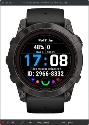
At the very first start / launch of the watch face, you get the following display, instead of the tide information, a 8-digit identification number: xxxx - xxxx.
It is this identifying number that you will need to communicate to me by email, so that I can calculate your personal activation code, once you have paid for it via one of the 2 PayPal buttons located at the top of this page.
Once your activation code has been received, you will need to enter it, either via the integrated menu on the dial ("Tools -> Activation Code" menu), or via Garmin Connect. The code, as well as the identifier, are permanently stored on the watch.

Displayed when no data is available in the tide data storage table.
It happens:
- at the very first start of the application, when no request has yet been executed
- when a query has already been executed, but the array is empty; you must then restart a new query

Access to the integrated menu of the watch face
To access the integrated menu (only on compatible models), proceed as follows:
1- position yourself on the Tides screen
2- long press on the UP key (or long press on the touch screen) -> a menu is displayed
3- select the "Watch face" menu
4- select the "Tides" dial using the dial selection carousel
5- press the START key, a sub-menu is displayed
6- select the first "Customize" submenu; this screen is then displayed, which allows you to access all the configuration options of the dial

Screen specific to Instinct 2 and 2S models

Complications

Some integrated menus
Menu of tides table

First data stored into the table

Next data, first tide of the following day

Last data stored into the table
Acquiring the Lat-Lon GPS coordinates of the spot

No GPS location fixed

A GPS position has just been acquired

Immediate display of the position in the menu
Tides menu options

Forces the acquisition of new data by launching a new web request, even if the stored array still contains data. This allows you to refresh the table at the date / time of the execution of the query.

Number of forecast days that the web request will take into account, from 1 day minimum to 5 days maximum.

Website used for the web request, either StormGlass or WorldTides Info, as desired.